|
|
Section 5Plotting Basics |
|
|
Section 5Plotting Basics |
5.3 |
Dead Reckoning and Fixes |
|
Lesson 5.1 covered how to plot a course and 5.2 explained the use of the distance, speed and time formulas. This lesson builds on those two skills and demonstrates how to plot a dead reckoning or DR course. It's uncertain where the term "dead reckoning" came from, but it's probably from "deduced" reckoning. "Dead" doesn't refer to the fate of sailors who don't practice it, but it could. Boats and mariners have been lost from failure to maintain an accurate reckoning of course and position. |
||
Plotting a DR CourseNavigating by dead reckoning involves calculating a new position or positions from a known departure point using estimates of speed, course and elapsed time. The DR course is plotted on the chart with a series of DR positions and may indicate the intended path of travel. Sometimes it is a planning tool only, as the known path of travel will be elsewhere. This occurs in waters with currents. This subject will be covered in Section 8. A DR course should be plotted, in advance, or from the moment a boat leaves harbour or weighs anchor, until safe arrival at its destination. The plotted course allows the navigator to avoid hazards and plan and monitor an efficient route. The DR positions along the route at regular intervals provide approximations of the boat's position relative to a known position. In an emergency a DR position may serve as the best guess of the boat's real position. |
Starting With a FixA navigator's prime concern is to know the boat's position at all times. Sometimes there's no doubt where it is: secure in a known anchorage, for example. Close aboard a charted buoy the navigator can be almost absolutely certain of the boat's position. However, in open water the navigator should be wary. Is the chart up to date and is the buoy in the right place and correctly identified? Highly reliable positions can be obtained by the Global Positioning System (GPS) or other satellite or electronic positioning systems. A fix is a position of which the navigator is highly confident. The act of establishing a fix is called "getting a fix" or "fixing a position". Sections 6 and 7 look at methods of fixing a position. Important: A dead reckoning (DR) course always begins at a fix. |
Errors and AccuracyIf a skipper steers a course due south at a speed of five knots, after one hour the boat's position by dead reckoning should be five nautical miles south of where it started. Actually, it's unlikely that it will be there. It'll probably be close to where it should be, but steering errors, an out-of-date deviation table, leeway, drifting due to current, and other factors will likely put the boat off course. So why bother plotting a DR course at all? There are two reasons; first, it's better to have an inaccurate idea of where you are than to have no idea at all; and second, it's only by starting with a DR course that you can determine how much the boat has been nudged off course, at what rate and in which direction. You can then figure out what could be causing these errors and take action to correct them. |
Dead Reckoning TodayNavigating by DR has been used since the time of Columbus and it's still the fundamental basis of course planning today. Even high-tech navigational aids such as electronic plotters, radar and GPS can't replace dead reckoning. DR plotting isn't just a backup in case electronic instruments fail, although that would be reason enough to use it. With a plotted representation of a boat's course on the water, a navigator can see what lies ahead on the chart. The unwary boater who has neglected to plot his intended path and position would have no warning of impending dangers. |
DR PrinciplesHere are five golden rules for plotting a DR course:
|
|
Labeling ConventionsSailing and power boating schools world wide, and coast guard, military and merchant marine institutions teach essentially the same plotting and labeling conventions. These conventions are tried and proven. With the same system taught everywhere, all navigators speak the same navigational language. They can understand each other's log books and chart notations, and readily take over from one another at the helm. |
|
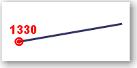
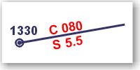
A fix is plotted as a small circle with a dot in its centre. It's labeled with the time, using the 24-hour notation, printed parallel to the bottom of the chart (to show that it's known with certainty). |
|
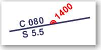
The course is placed above the plotted line and labeled with a C, followed by a space and the three-digit heading. If a magnetic or compass course is plotted instead of true — not recommended, as you know by now — it should be indicated with an M or a C following the course. Speed is placed below the line under the course, labeled with an S, and noted to tenths of a knot. |
|
DR positions are marked on the plotted course line. The symbol is a small semi-circle above the line with a small dot or short stroke at its centre. The DR position is labeled with the time or estimated time of arrival using the 24-hour notation. The time is entered at an angle to the bottom of the chart (to show that it's an estimate). |
|
||||||
|
|
Get Help |
|
|
|
|
|
|